КАТЕГОРИИ:
Архитектура-(3434)Астрономия-(809)Биология-(7483)Биотехнологии-(1457)Военное дело-(14632)Высокие технологии-(1363)География-(913)Геология-(1438)Государство-(451)Демография-(1065)Дом-(47672)Журналистика и СМИ-(912)Изобретательство-(14524)Иностранные языки-(4268)Информатика-(17799)Искусство-(1338)История-(13644)Компьютеры-(11121)Косметика-(55)Кулинария-(373)Культура-(8427)Лингвистика-(374)Литература-(1642)Маркетинг-(23702)Математика-(16968)Машиностроение-(1700)Медицина-(12668)Менеджмент-(24684)Механика-(15423)Науковедение-(506)Образование-(11852)Охрана труда-(3308)Педагогика-(5571)Полиграфия-(1312)Политика-(7869)Право-(5454)Приборостроение-(1369)Программирование-(2801)Производство-(97182)Промышленность-(8706)Психология-(18388)Религия-(3217)Связь-(10668)Сельское хозяйство-(299)Социология-(6455)Спорт-(42831)Строительство-(4793)Торговля-(5050)Транспорт-(2929)Туризм-(1568)Физика-(3942)Философия-(17015)Финансы-(26596)Химия-(22929)Экология-(12095)Экономика-(9961)Электроника-(8441)Электротехника-(4623)Энергетика-(12629)Юриспруденция-(1492)Ядерная техника-(1748)
Regional transport systems of the world (part 4)
|
|
|
|
Lecture Outline
1. Overview of transport system of the African continent.
2. Features of the transport system of South Africa.
3. Transport systems of Nigeria, Kenya and the Democratic Republic of Congo.
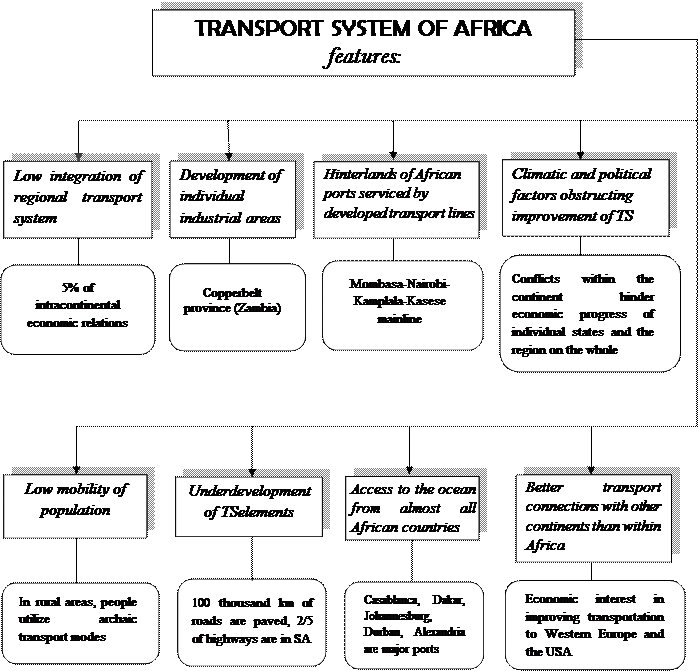
Core elements of transport system development in Africa are cities and urban areas which rely on specific transportation network. Such transportation network combines communication ways, various hauling distances, formation of coastal and inland mono- and polyfunctional nodes. Sea ports and areas around them have major effect on economic development of the continent. Figure 1.1 shows the basic features of the African transport system.
Africa’s industrial development zones (IDZs), like Shaba province in south western Congo, Сopperbelt province in Zambia (a copper mining area in the northwest of the country), Witwatersrand in South Africa (a region of northeast South Africa between the Vaal River and Johannesburg which has been one of the richest gold-mining areas in the world since 1886), and East African Rift (a part of the African Great Lakes area, including Nairobi) are 600 to 1 500 km away from the coast. All these geographical factors defined the unique transport situation of African continent: the average hauling distance by main transportation routes is 1,5 to 2 times longer than in other developing countries and regions.
Spatial structure of the economy depends on the level of development and location of transport infrastructure. Drastic regional disproportions are maintained because of inadequacy (gauge difference, in particular) and stagnation of the existing networks.
Transport connections between the states within the continent are weak. The countries are oriented overseas in their economic and transportation activity. Only 5% of economic relations are intracontinental.
Hinterlands of African ports expand over vast territories and extend beyond political borders of countries. On some routes which link the ports with the inland industrial development zones, multiple mainlines are formed, such as Mombasa-Nairobi-Kampala-Kasese; Dar es Salaam to central Zambia; Durban-Johannesburg; Alexandria-Cairo-Aswan, etc.
The share of road transportation in national cargo traffic has slightly grown, approaching 30% in 2011. African transport system has been formed mainly during the colonial period and subordinated to the interests of metropolitan areas. The main purpose of that system was to connect sea ports with the mining regions and agricultural economies aimed at export of goods.
Modern construction of transport facilities on the continent is hindered by climatic, political and economic factors. Vast areas of deserts and rain forests, political conflicts between the states and economic weakness of individual countries are major obstructions to development of African transport system. The only modern complex transport system in Africa is the South African transport system.
In estimating African transportation, we need to take account of low mobility of the population, underdeveloped contacts between the states and utilization of archaic transport modes by local population in rural areas (in deserts, rain forests and mountainous regions).
All modern transport modes in Africa are underdeveloped. 100 000 km of continental highways are paved, 2/5 of highways are located in South Africa. Road transport is characterized by small amount of operating vehicles. The length of railways is 95 000 km, ¼ of railways is in the Republic of South Africa and 1/6 of railways are located in North Africa. South African railways are of international importance, especially the transcontinental railway from Tanzania to Angola (Dar es Salaam – Lobito) which provides access to the ocean for the Copperbelt province of Congo and Zambia. River links have local economic impact only. Seasonal character of feeding African rivers and numerous waterfalls hold back navigation. Congo, Nile and Niger have combined water-road transport systems for detour.
With a few exceptions, all African countries have access to the ocean and their overseas relations are maintained via maritime ports. The busiest ports in terms of freight traffic are specialized ports serving as export centers for large tonnage raw materials and fuels like oil, coal, iron ore and phosphorites. Major ports are Casablanca, Dakar, Capetown, Port Said, Durban and Alexandria. Most cargo is transported to and from Africa by foreign vessels. The large trade fleet of Liberia is, in fact, maintained by the ship owners from the USA, Greece and other European countries using the ‘cheap’ Liberian flag.
A lot of African countries are serviced by their own air transport. The major African airlines are South African Airways, EgyptAir (Cairo International Airport) and Nigeria Airways, by international airports of Casablanca, Dakar, Tripoli, Kinshasa, Cairo, Nairobi, Johannesburg.
Transport connections between the states within Africa are a specific problem. Many African countries maintain better transport connections with Western Europe and the USA than with neighboring states. Lack of economic interest is the main obstacle in developing projects for trans-African transport routes, e.g. across the Sahara from Algeria to Nigeria, along Sahel from Senegal to Chad, from the Indian Ocean to the Atlantic coast (Kenya – Nigeria) and from Egypt to Botswana.
Suez Canal is the artificial waterway running north to south across the Isthmus of Suez in northeastern Egypt; it connects the Mediterranean Sea with the Gulf of Suez. The canal provides a shortcut for ships operating between both European and American ports and ports located in southern Asia, eastern Africa, and Oceania.
The Suez Canal is 195 km long. The minimum bottom width of the channel is 60 m and ships of 16 m draft can make the transit. The canal can accommodate ships as large as 150,000 dead weight tons fully loaded. It has no locks, because the Mediterranean Sea and the Gulf of Suez have roughly the same water level. Most of the canal is limited to a single lane of traffic, but several passing bays exist. A railroad on the west bank runs parallel to the canal for its entire distance.
Figure 1.1 Features of African transport system
South Africa has a modern and well developed transport infrastructure. The roads are world-class. The air and rail networks are the largest on the continent. And the country's ports provide a natural stopover for shipping to and from Europe, the Americas, Asia, Australasia and both coasts of Africa. The transport sector has been highlighted by the government as a key contributor to South Africa's competitiveness in global markets. It is increasingly being seen a crucial engine for economic growth and social development, and the government has unveiled plans to spend billions of rands to improve the country's roads, railways and ports.
Major shipping lanes pass along the South African coastline in the south Atlantic and Indian oceans. Approximately 96% of the country's exports are conveyed by sea, and the eight commercial ports are the conduits for trade between South Africa and its southern African partners as well as hubs for traffic to and from Europe, Asia, the Americas and the east and west coasts of Africa.
The state-owned Transnet National Ports Authority manages the country's ports. These are: Richards Bay and Durban in KwaZulu-Natal; East London, Port Elizabeth; and Mossel Bay, Cape Town and Saldanha in the Western Cape.
Durban is Africa's busiest port and the largest container facility in southern Africa, while Richard's Bay is the world's largest bulk coal terminal.
South Africa's total road network is about 754 000 kilometres, of which over 70 000km are paved or surfaced roads. The drive from Messina on South Africa's northern border to Cape Town in the south is a 2 000km journey on well-maintained roads.
Around 3 000 km of the national roads are toll roads. About 1 800km of these are maintained by Sanral, while the rest have been concessioned to private companies to develop, operate and maintain.
A multi-billion rand freeway improvement scheme has significantly eased congestion on the roads in Gauteng, the country's busiest province.
South Africa has an extensive rail network – the 14th longest in the world – connecting with networks in the sub-Saharan region. The country's rail infrastructure, which connects the ports with the rest of South Africa, represents about 80% of Africa's total.
State-owned Transnet Freight Rail is the largest railroad and heavy haulier in southern Africa, with about 21 000km of rail network, of which about 1 500km are heavy haul lines. Just over 8 200km of the lines are electrified.
The Gautrain, an 80km rapid rail network, connects Johannesburg, Pretoria and OR Tambo International Airport since mid-2011, easing congestion on the Joburg-Pretoria highway by offering commuters a safe alternative to road travel.
Sixty-two airlines, making 274 000 aircraft landings and carrying 16.5-million passengers (counting departures only), moved through South Africa's 10 principal airports in 2009.
The 10 airports are run by Airports Company South Africa, and handle over 98% of the country's commercial air traffic. They comprise major international airports in Johannesburg, Cape Town and Durban, as well as airports in Bloemfontein, Port Elizabeth, East London, George, Kimberly, Pilansberg and Upington.
Acsa invested about R20-billion in South Africa's airports in the run-up to the 2010 Fifa World Cup, with major upgrades to Johannesburg's OR Tambo International Airport and Cape Town International Airport.
The old Durban International Airport was shut down and replaced by King Shaka International Airport to the north of Durban, built from scratch at a cost of R7.9-billion.
The Airports Council International named Cape Town International the best airport in Africa in 2011. OR Tambo International, Africa's busiest airport, was named third best and King Shaka International fourth best airport on the continent.
South African Airways (SAA) is by far the largest air carrier in Africa, with connections to more than 20 cities across the continent. As a Star Alliance member, SAA also offers its customers 975 destinations in 162 countries and 18 100 flights daily.
There are 931 km of crude oil pipeline transport, 1 748 km for other petroleum products, and 322 km for natural gas.
Nigeria, republic in western Africa, bounded by Cameroon to the east, Chad to the northeast, Niger to the north, Benin to the west, and the Atlantic Ocean to the south. Until 1991, the capital was the largest city, Lagos, on the southwestern coast; at that time, the new city of Abuja, in the country’s interior, became capital.
Nigeria has 194,394 km of roads. Most Nigerians travel by bus or taxi both between and within cities. During the 1970s and 1980s federal and state governments built and upgraded numerous expressways and transregional trunk roads. State governments also upgraded smaller roads, which helped open rural areas to development. However, by the mid-1990s lack of investment had left most of the roads to deteriorate.
Nigeria has 3,505 km of operated railway track. The main line, completed in 1911, links Lagos to Kano, with extensions from Kano to Nguru, from Zaria to Kaura Namoda, and from Minna to Baro. The use of railways, both for passenger and freight traffic, has declined due to competition from the road network.
Nigeria’s largest ocean ports are at Lagos (Apapa and Tin Can Island), Port Harcourt, Calabar, Sapele, and Warri. The main petroleum-exporting facilities are at Bonny and Burutu. Transportation along inland waterways, especially the Niger and Benue rivers, was very important during the colonial era. In the late 1980s the government upgraded river ports at Onitsha, Ajaokuta, Lokoja, Baro, Jebba, and Yelwa. Locks have been constructed at Kainji Dam to facilitate navigation. River transport is used mainly for shipping goods.
Nigeria has two major international airports, one in the Lagos suburb of Ikeja and the other in Kano. Internal flights serve the majority of state capitals, of which Kaduna, Port Harcourt, and Enugu are the busiest. Nigeria Airways, the national carrier, offers both domestic and international flights. Several small regional carriers also compete for domestic traffic.
Kenya has one of the most extensive transportation networks in East Africa. Railways connect the major cities, and the country’s road network is substantial, although more than 80 percent of roads are unpaved. Mombasa is Kenya’s major seaport and serves Uganda and Rwanda as well. Kisumu is the major port on Lake Victoria. River transport is not extensive. International airports are located at Nairobi, Mombasa, and Eldoret. Kenya Airways is the national airline. The main forms of public transportation in Kenya are buses, matatus (minibuses), and taxis.
Roads in the Democratic Republic of Congo are in generally poor repair, hindering the transport of crops to markets and contributing to the decline of export agriculture. The total length of the national road system is about 157,000 km. The country’s 4,752 km of aging railways provide important connections domestically as well as with the Angolan port of Benguela and with southern Africa.
Inland waterways are used extensively. The Congo River is navigable from its mouth to Matadi, a distance of 134 km. The river is unnavigable from Matadi to Kinshasa, which are linked by a railway 401 km long. Beyond Kinshasa navigation is possible for more than 1,600 km until Stanley Falls impedes navigation at Kisangani. The unnavigable portions of the Congo require exports from the southeast region of Katanga to be sent through other countries. Navigable inland waterways total about 13,700 km.
For most Congolese, the chief modes of river transportation remain aging river steamers and long canoes, known as pirogues. The principal seaports are Matadi and Boma, on the lower Congo River, and Banana, at the river’s mouth. The country has five international airports, at Kinshasa, Lubumbashi, Kisangani, Goma, and Gbadolite. State-owned Congo Airlines provides domestic and international service.
Countries for self-study:
1. Egypt
2. Tanzania
3. Angola
4. Algeria
5. Morocco
6. Senegal
7. Gambia
8. Sudan
|
|
|
|
Дата добавления: 2014-01-11; Просмотров: 808; Нарушение авторских прав?; Мы поможем в написании вашей работы!