КАТЕГОРИИ:
Архитектура-(3434)Астрономия-(809)Биология-(7483)Биотехнологии-(1457)Военное дело-(14632)Высокие технологии-(1363)География-(913)Геология-(1438)Государство-(451)Демография-(1065)Дом-(47672)Журналистика и СМИ-(912)Изобретательство-(14524)Иностранные языки-(4268)Информатика-(17799)Искусство-(1338)История-(13644)Компьютеры-(11121)Косметика-(55)Кулинария-(373)Культура-(8427)Лингвистика-(374)Литература-(1642)Маркетинг-(23702)Математика-(16968)Машиностроение-(1700)Медицина-(12668)Менеджмент-(24684)Механика-(15423)Науковедение-(506)Образование-(11852)Охрана труда-(3308)Педагогика-(5571)Полиграфия-(1312)Политика-(7869)Право-(5454)Приборостроение-(1369)Программирование-(2801)Производство-(97182)Промышленность-(8706)Психология-(18388)Религия-(3217)Связь-(10668)Сельское хозяйство-(299)Социология-(6455)Спорт-(42831)Строительство-(4793)Торговля-(5050)Транспорт-(2929)Туризм-(1568)Физика-(3942)Философия-(17015)Финансы-(26596)Химия-(22929)Экология-(12095)Экономика-(9961)Электроника-(8441)Электротехника-(4623)Энергетика-(12629)Юриспруденция-(1492)Ядерная техника-(1748)
Geography and cultural regions of the U. S. A
|
|
|
|
LECTURE 1
This lecture will describe the land, physical features, and climate of the United States of America, and cover the following items:
· the U. S. political geography and political divisions,
· origin of states' names,
· the U.S. capital and largest cities,
· the U.S. politics,
· physical geography: major lakes and river systems, U.S. deserts,
· climate, environment,
· large country with many cultural differences,
· cultural regions: the Northeast, the South, the West, the Midwest, the Southwest,
· Americanization.
Key Words and Proper Names: adjacent, arid (semi-arid), as of 2013 U.S. Census Bureau estimates, contiguous, converge, county, cultural identity, drainage, drawl, extant political entities, extraction, fossil fuel, freight, gorge, homogenizing influence, intermixing of cultures, level off regional differences, metro area, offshore rig, parish, precipitation, patois, pronounced peculiarities, resentment, reverence for the past, startling, statehood, thrift, tolerance, township, tributary, urban sprawl;
Native American tribes; the Appalachian Mountains, the Adirondacks, the Cordilleran system, the Great Plains, the Interior Highlands, the Interior Plains, the Ozark Plateau, the Intermontane Plateaus, the Laurentian Highlands, the Rocky Mountains; the Great Lakes (Superior, Huron, Michigan, Ontario, and Erie), the St. Lawrence River, the Mississippi-Missouri rivers; the Colorado Desert, the Great Basin, the Mojave Desert, the Sonoran Desert, Sunbelt and Frostbelt;
William Faulkner, Flannery O'Connor, Carson McCullers, Katherine Anne Porter, Robert Penn Warren, Eudora Welty, Tennessee Williams, Thomas Wolfe.
The United States of America is a constitutional federal republic, it comprises 50 states and one federal district, and has several territories in the Caribbean and Pacific.
To call the country as America is not absolutely correct. It is called as the United States, the U.S., the U.S.A., the U. S. of A., America, the States, or (poetically ) Columbia depending on a degree of formality
In 1507, German cartographer Martin Waldseemüller made a world map on which he named the lands of the Western Hemisphere as "America" after Amerigo Vespucci, Italian explorer and cartographer.
The country's modern name was first used in the Declaration of Independence, as the "unanimous Declaration of the 13 united States of America" adopted by the "Representatives of the united States of America" on July 4, 1776. The current name was finalized on November 15, 1777, when the Second Continental Congress adopted the Articles of Confederation, they state, "The Stile (name) of this Confederacy shall be 'The United States of America."
The United States of America is the third largest country in the world after Russia and Canada with an area of 9,826,630 (9.8) sq km.
The estimated U.S. population as of July 2014 was 318,662,000 people including an approximate 11.2 million illegal immigrants. So, in size of population it is also the third in the world behind China and India.
The US political geography: The U.S.has the longest undefended ground border in the world with Canada and also shares a long ground border with Mexico.
The country is divided into three distinct sections:
a) the continental United States also known as the lower 48;
b) Alaska, which is physically connected only to Canada,
c) and the archipelago of Hawaii in the central Pacific Ocean.
49 states (all except Hawaii) lie on the North American continent; and 48 of them (all except Alaska) are contiguous and form the continental United States.
Fig.1. 50 American states 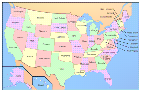
The state’s names are: Alabama, Alaska, Arizona, Arkansas, California, Colorado, Connecticut, Delaware, Florida, Georgia, Hawaii, Idaho, Illinois, Indiana, Iowa, Kansas, Kentucky, Louisiana, Maine, Maryland, Massachusetts, Michigan, Minnesota, Mississippi, Missouri, Montana, Nebraska, Nevada, New Hampshire, New Jersey, New Mexico, New York, North Carolina, North Dakota, Ohio, Oklahoma, Oregon, Pennsylvania, Rhode Island, South Carolina, South Dakota, Tennessee, Texas, Utah, Vermont, Virginia, Washington, West Virginia, Wisconsin, Wyoming.
As said above, the U.S. also holds several other territories, districts and possessions, first of all, the federal district called the District of Columbia, which is the nation’s capital, and several overseas areas, the most significant of which are Puerto Rico, American Samoa, Guam, Northern Mariana Islands, and the United States Virgin Islands. The U.S. Navy has held one military base called Guantanamo at an occupied portion of Guantanamo Bay on Cuba since 1898.
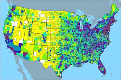
The 50 U.S. states vary widely in size and population (Fig.2). The largest states in area are Alaska with an area of 1.7 ml sq km, followed by Texas, and California. The smallest state is Rhode Island, with an area of 4,002 sq km. The state with the largest population is California (35.8 ml people), followed by Texas, and New York. Only a bit more than 500,000 people live in Wyoming, which is also the least populous state. New Jersey, on the other hand, is the most densely populated state.
Fig.2. The U.S. population density
Interesting to know: State names speak to the circumstances of their creation. We may find:
British names. Southern states on the Atlantic coast originated as British colonies named after British monarchs: Georgia, the Carolinas, Virginia, and Maryland. Some northeastern states, also former British colonies, take their names from places in the British Isles: New Hampshire, New Jersey, and New York.
Native American names. Many states' names are those of Native American tribes or are from Native American languages: Nebraska, Kansas, Massachusetts, Hawaii, Connecticut, Missouri, Idaho, Iowa, Wisconsin, Illinois, Minnesota, the Dakotas, Mississippi, Texas, Utah, and others.
Spanish names. M any states in the southeast and southwest have Spanish names, because they are on territories previously controlled by Spain or Mexico. They include Colorado, New Mexico, Florida, California and Nevada.
French names. Because it was previously a French colony, Louisiana is named after the Louis XIV (King of France at the time).
Washington, D.C., orthe District of Columbia (also known as the Nation's Capital; the District; and, historically, the Federal City) is the capital city and administrative district of the U.S.A.
Washington, D.C. is a part of the Baltimore-Washington Metropolitan Area, which includes parts of Maryland, Virginia, and West Virginia. It should not be confused with the U.S. state of Washington, located in the Pacific Northwest.
The District of Columbia is a federal district. As specified by the U.S. Constitution, the District is ruled by the U.S. Congress, though it is unrepresented in that body. The population of the District of Columbia is more than 5 mln people.
The centers of all three branches of the U.S. federal government are situated in Washington, D.C., as well as the headquarters of most federal agencies. Washington also serves as the headquarters for the World Bank, the International Monetary Fund, and the Organization of American States, and other international (and national) institutions. Washington is also the site of numerous national landmarks, museums, and is a popular destination for tourists.
Largest cities: The U.S. has dozens of major cities, including several important global cities such as New York City, Los Angeles, and Chicago. The figures expressed below are for populations within 10 city limits (as of 2013 U.S. Census Bureau estimates).
| Rank City 1.New York City 2. Los Angeles 3. Chicago 4. Dallas 5. Houston 6. Philadelphia 7. Washington, D.C. 8. Miami 9. Atlanta 10. Boston 11. San Francisco | Population 19, 949,502 13,131,431 9,537,289 6,810,913 6,313,158 6,034,678 5,949,859 5,828,191 5,522,942 4,684,299 4,516,276 | Region Northeast West Midwest South South Northeast Northeast South South Northeast West |
Extensive areas of urban sprawl exist in larger metropolitan areas such as Los Angeles, California; Chicago, Illinois; and New York City.
The U.S. politics: The states are generally divided into smaller administrative regions, including counties, cities and townships, with the exception of Louisiana, where counties are called parishes, and incorporate cities, villages, towns. Altogether, there are an estimated 85,000 extant political entities in the U.S. including counties, municipalities, townships, school districts, and special districts.
The U.S. politics is represented by 50 state governments plus the government of the District of Columbia, and further down the ladder are still smaller units that govern counties, cities, towns, boroughs and villages.
Like the national government, state governments have three branches: executive, legislative, and judicial; these are roughly equivalent in function and scope to their national counterparts. The chief executive of a state is the governor, elected by popular vote typically for a four-year term (although in a few states the term is two years).
All states have a bicameral legislature, the upper house is usually called the Senate and the lower house is called the House of Representatives, the House of Delegates, or the General Assembly, except for Nebraska, which has a unicameral legislature.
There are three general types of city government: the mayor-council, the commission, and the council-manager. These are the pure forms; many cities have developed a combination of two or three of them. Almost all city governments have some kind of central council, elected by the voters, an executive officer or mayor, assisted by various department heads, to manage the city’s affairs, a judge as well as a sheriff to provide law enforcement services.
51st state: The phrase 51st state refers to the territories considered candidates for addition to the 50 states of the country. The District of Columbia is widely recognized to be one of the most likely candidates for statehood. Currently Puerto Rico claims its statehood.
At the same time the phrase 51st state is often used in a humorous or even negative context referring to associates, which act based on American influences, such as Israel, Canada or the United Kingdom. This term also signifies excessive negative American influence. In Europe, people who believe their local or national culture has become too Americanized sometimes use the term “ 51st state ” in critical reference to their respective countries and governments.
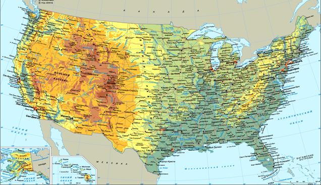
Physical geography: The geography of the U.S. varies across its immense area from temperate forestland to deserts and rain forests, Alaska’s tundra and the volcanic, tropical islands of Hawaii.
Within the continental U.S., 8 there are distinct physiographic divisions. They are the:
· Laurentian Highlands – It is a part of the Canadian Shield that extends into the northern U.S. Great Lakes area.
· Atlantic Plains – these are coastal regions of the eastern and southern parts including the continental shelf, the Atlantic Coast and the Gulf Coast.
· Appalachian Highlands - lying on the eastern side of the U.S., it includes the Appalachian Mountains, Adirondacks and New England province.
· Interior Plains – this part of the interior continental U.S. includes much of what is called the Great Plains.
· Interior Highlands – It is also a part of the interior continental U.S. and includes the Ozark Plateau.
· Rocky Mountain System – It is one branch of the Cordilleran system lying far inland in the western states.
· Intermountain Plateaus - it is a system of plateaus, basins, ranges and gorges between the Rocky and Pacific Mountain Systems. It is the setting for the Grand Canyon, the Great Basin and Death Valley.
· Pacific Mountain System – these are coastal mountain ranges and features in the west coast of the U.S.
Fig.3. The U.S.A. physical geography
Major lakes and river systems: All the waters east of the Rockies finally reach the Atlantic; all the waters to the west of the Rockies finally arrive at the Pacific. For this reason the Rocky Mountains are known as the Continental Divide.
Two enormous drainage systems dominate the U.S. landscape: the Great Lakes-St. Lawrence River and the Mississippi-Missouri rivers drainage areas. More than 75% of the freight transported along U.S. inland waterways moves on these waterways.
Here, comes the list of the major 11 rivers of the USA and their length in km.
|
|
|
|
|
Дата добавления: 2014-11-16; Просмотров: 2190; Нарушение авторских прав?; Мы поможем в написании вашей работы!