КАТЕГОРИИ:
Архитектура-(3434)Астрономия-(809)Биология-(7483)Биотехнологии-(1457)Военное дело-(14632)Высокие технологии-(1363)География-(913)Геология-(1438)Государство-(451)Демография-(1065)Дом-(47672)Журналистика и СМИ-(912)Изобретательство-(14524)Иностранные языки-(4268)Информатика-(17799)Искусство-(1338)История-(13644)Компьютеры-(11121)Косметика-(55)Кулинария-(373)Культура-(8427)Лингвистика-(374)Литература-(1642)Маркетинг-(23702)Математика-(16968)Машиностроение-(1700)Медицина-(12668)Менеджмент-(24684)Механика-(15423)Науковедение-(506)Образование-(11852)Охрана труда-(3308)Педагогика-(5571)Полиграфия-(1312)Политика-(7869)Право-(5454)Приборостроение-(1369)Программирование-(2801)Производство-(97182)Промышленность-(8706)Психология-(18388)Религия-(3217)Связь-(10668)Сельское хозяйство-(299)Социология-(6455)Спорт-(42831)Строительство-(4793)Торговля-(5050)Транспорт-(2929)Туризм-(1568)Физика-(3942)Философия-(17015)Финансы-(26596)Химия-(22929)Экология-(12095)Экономика-(9961)Электроника-(8441)Электротехника-(4623)Энергетика-(12629)Юриспруденция-(1492)Ядерная техника-(1748)
Multi-modal transportation planning
|
|
|
|
Text 5
 Conventional (also called traditional or business as usual) transportation planning refers to current practices for making transport policy, investment and design decisions. Multi-modal planning refers to planning that considers various modes (walking, cycling, automobile, public transit, etc.) and connections among modes. There are several specific types of transport planning for reflecting different scales and objectives:
Traffic impact studies evaluate traffic impacts and mitigation strategies for a particular development or project.
Local transport planning develops municipal and neighborhood transport plans.
Regional transportation planning develops plans for a metropolitan region.
State, provincial and national transportation planning develops plans for a large jurisdiction, to be implemented by a transportation agency.
Strategic transportation plans develop long-range plans, typically 20-40 years into the future.
Transportation improvement plans (TIPs) or action plans identify specific projects and programs to be implemented within a few years.
Corridor transportation plans identify projects and programs to be implemented on a specific corridor, such as along a particular highway, bridge or route.
Mode- or area-specific transport plans identify ways to improve a particular mode (walking, cycling, public transit, etc.) or area (a campus, downtown, industrial park, etc.).
A transport planning process typically includes the following steps:
Monitor existing conditions.
Forecast future population and employment growth, and identify major growth corridors.
Identify current and projected future transport problems and needs, and various projects and strategies to address those needs.
Evaluate and prioritize potential improvement projects and strategies.
Develop long-range plans and short-range programs identifying specific capital projects and operational strategies.
Develop a financial plan for implementing the selected projects and strategies.
Conventional transportation planning strives to maximize traffic speeds, minimize congestion and reduce crash rates (generally measured per vehicle-mile) using a well developed set of engineering, modeling and financing tools. Many jurisdictions codify these objectives in concurrency requirements and traffic impact fees, which require developers to finance roadway capacity expansion to offset any increase in local traffic. Alternatives to roadway expansion, such as transportation demand management and multi-modal transport planning, are newer and so have fewer analysis tools. As a result, conventional planning practices support automobile dependency, which refers to transport and land use patterns favoring automobile travel over alternative modes (in this case, automobile includes cars, vans, light trucks, SUVs and motorcycles).
In recent years transportation planning has expanded to include more emphasis on non-automobile modes and more consideration of factors such as environmental impacts and mobility for non-drivers. In recent decades many highway agencies have been renamed transportation agencies, and have added capacity related to environmental analysis, community involvement and nonmotorized planning. Some are applying more comprehensive and multi-modal evaluation (Litman 2012). Transport modeling techniques are improving to account for a wider range of options (such as alternative modes and pricing incentives) and impacts (such as pollution emissions and land use effects). In addition, an increasing portion of transport funds are flexible, meaning that they can be spent on a variety of types of programs and projects rather than just roadways.
Most regions use four-step models to predict future transport conditions (see Figure 1). The region is divided into numerous transportation analysis zones (TAZs) each containing a few hundred to a few thousand residents. Trip generation (the number and types of trips originating from each TAZ) is predicted 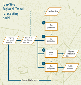 based on generic values adjusted based on local travel surveys that count zone-to-zone peak-period trips. These trips are assigned destinations, modes and routes based on their generalized costs (combined time and financial costs), with more trips assigned
Figure 1. Four-Step Traffic Model
to relatively cheaper routes and modes, taking into account factors such as travel speeds, congestion delays and parking costs. Transport models are being improved in various ways to better predict future travel activity, including the effects of various transport and land use management strategies.
This predicts future peak-period traffic volumes on each route, and identifies where volumes will exceed capacity (based on the volume/capacity ratio or V/C) of specific roadway links and intersections. The intensity of congestion on major roadways is evaluated using level-of-service (LOS) ratings, a grade from A (best) to F (worst).
Under optimal conditions a grade separated highway can carry up to 2,200 vehicles per hour (VPH) per lane. An arterial with intersections can carry about half that. Table 3 indicates units commonly used to measure traffic. These are generally measured during peak hours. Speed is generally based on the 85th percentile (the speed below which 85% of vehicles travel). Traffic volumes are also sometimes measured as Annual Average Daily Traffic (AADT), indicating traffic volumes averaged over a year.
A typical transport planning process defines the minimum level-of-service considered acceptable (typically LOS C or D). Roads that exceed this are considered to fail and so deserve expansion or other interventions. This approach is criticized on these grounds:
It focuses primarily on motor vehicle travel conditions. It assumes that transportation generally consists of automobile travel, often giving little consideration to travel conditions experienced by other modes. As a result, it tends to result in automobile dependency, reducing modal diversity.
It defines transportation problems primarily as traffic congestion, ignoring other types of problems such as inadequate mobility for non-drivers, the cost burden of vehicle ownership to consumers and parking costs to businesses, accident risk, and undesirable social and environmental impacts.
It ignores the tendency of traffic congestion to maintain equilibrium (as congestion increases, traffic demand on a corridor stops growing), and the impacts of generated traffic (additional peak-period vehicle travel that results from expanded congested roadways) and induced travel (total increases in vehicle travel that result from expanded congested roadways). As a result, it exaggerates the degree of future traffic congestion problems, the congestion reduction benefits of expanding roads, and the increased external costs that can result from expanding congested roadways.
It can create a self-fulfilling prophecy by directing resources primarily toward roadway expansion at the expense of other modes (widening roads and increasing traffic speeds and volumes tends to degrade walking and cycling conditions, and often leaves little money or road space for improving other modes).
Short trips (within TAZs), travel by children, off-peak travel and recreational travel are often ignored or undercounted in travel surveys and other statistics, resulting in walking and cycling being undervalued in planning.
In recent years transportation planning has become more multi-modal and comprehensive, considering a wider range of options and impacts. Transport planners have started to apply Level-of-Service ratings to walking, cycling and public transit, and to consider demand management strategies as alternatives to roadway capacity expansion.
Some urban areas have established a transportation hierarchy which states that more resource efficient modes will be given priority over single occupant automobile travel, particularly on congested urban corridors. This provides a basis for shifting emphasis in transport planning, road space allocation, funding and pricing to favor more efficient modes.
√ Answer the questions.
1. Do you agree that transportation planning refers to current practices for making transport policy, investment and design decisions? 2. Does planning consider various modes and connections among modes? 3. What specific types of transport planning do you know? 4. What steps does a transport planning process typically include? 5. What do most regions use to predict future transport conditions? 6. What does a typical transport planning process define? 7. How many vehicles can a grade separated highway carry per hour (VPH) per lane under optimal conditions? 8. What have transport planners started to apply in recent years?
|
|
|
|
|
Дата добавления: 2014-11-29; Просмотров: 842; Нарушение авторских прав?; Мы поможем в написании вашей работы!