КАТЕГОРИИ:
Архитектура-(3434)Астрономия-(809)Биология-(7483)Биотехнологии-(1457)Военное дело-(14632)Высокие технологии-(1363)География-(913)Геология-(1438)Государство-(451)Демография-(1065)Дом-(47672)Журналистика и СМИ-(912)Изобретательство-(14524)Иностранные языки-(4268)Информатика-(17799)Искусство-(1338)История-(13644)Компьютеры-(11121)Косметика-(55)Кулинария-(373)Культура-(8427)Лингвистика-(374)Литература-(1642)Маркетинг-(23702)Математика-(16968)Машиностроение-(1700)Медицина-(12668)Менеджмент-(24684)Механика-(15423)Науковедение-(506)Образование-(11852)Охрана труда-(3308)Педагогика-(5571)Полиграфия-(1312)Политика-(7869)Право-(5454)Приборостроение-(1369)Программирование-(2801)Производство-(97182)Промышленность-(8706)Психология-(18388)Религия-(3217)Связь-(10668)Сельское хозяйство-(299)Социология-(6455)Спорт-(42831)Строительство-(4793)Торговля-(5050)Транспорт-(2929)Туризм-(1568)Физика-(3942)Философия-(17015)Финансы-(26596)Химия-(22929)Экология-(12095)Экономика-(9961)Электроника-(8441)Электротехника-(4623)Энергетика-(12629)Юриспруденция-(1492)Ядерная техника-(1748)
Analysis of the stationary mode of air movement
|
|
|
|
INTRODUCTION
When we need to describe a path and a road map to move the car to the specific goal, it is necessary to develop a plan to move it, with indicating the number of intersections, stop signs and gas stations, taking into account traffic jams and perform simulation [1-4].
To set up the model for path and road map to move the car run in MATLAB, since partition roadmap for individual intersections, it is necessary:
§ To indicate the roadmap, suppose they have bounds [-6 - 6] (Figure-1);
§ Split into sectors roadmap (junctions), we assume that there are six sectors and are arranged symmetrically;
where: xi, yi path describing the location of intersections and major roads.
As can be seen from (Figure-1) that coordinate trajectory consists of three intersections, three major roads and highways.
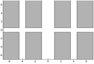
Figure-1. Border road map.
§ For continue modeling process point out stop signs, signs on roads and location of fuel tanks.
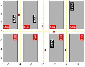
Figure-2. Full roadmap with delay elements.
As can be seen from (Figure-2) delay elements are appear on the map like «Stop» sign, distance to the nearest gas station «Station» or sudden appearance of gridlock. And the roads are unloading items randomly «Start» signs and approximate distance to the target and taking into account the situation on the road will have the picture shown in Figure-3.
These elements are the basic input parameters automatic route optimization system of the vehicle, where the output parameter is the distance to the final goal, but the result of the work - calculation of the optimal time depending on the initial.
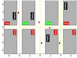
Figure-3. Full roadmap with elements of unloading.
|
|
|
|
|
Дата добавления: 2015-07-02; Просмотров: 298; Нарушение авторских прав?; Мы поможем в написании вашей работы!